
This spring, the Latvian cultural canon has been supplemented by a new section entitled “Landscapes”. It includes eight canonical landscapes of Latvia – the Daugava River Landscape, the Zemgale Plain Landscape, the Gauja Primeval Valley Landscape, the Latgalian Lake District Landscape (ezeraines), the Landscape of Latvian Forests, the Seacoast Landscape, the Landscape of Vidzeme Hillocks and Abava Primeval Valley Landscape.
These landscapes represent the beauty and diversity of the Latvian nature, formed in the interaction between the Man and Natural Environment. All eight canonical landscapes can be found at https://kulturaskanons.lv/list/?l=8#landscapes
We have published a description prepared by Oļģerts Nikodemus, Latvian geographer, professor at the University of Latvia (from 2002); a corresponding member of the Latvian Academy of Sciences (from 2005), which is available at kulturaskanons.lv/list/?l=8#landscapes
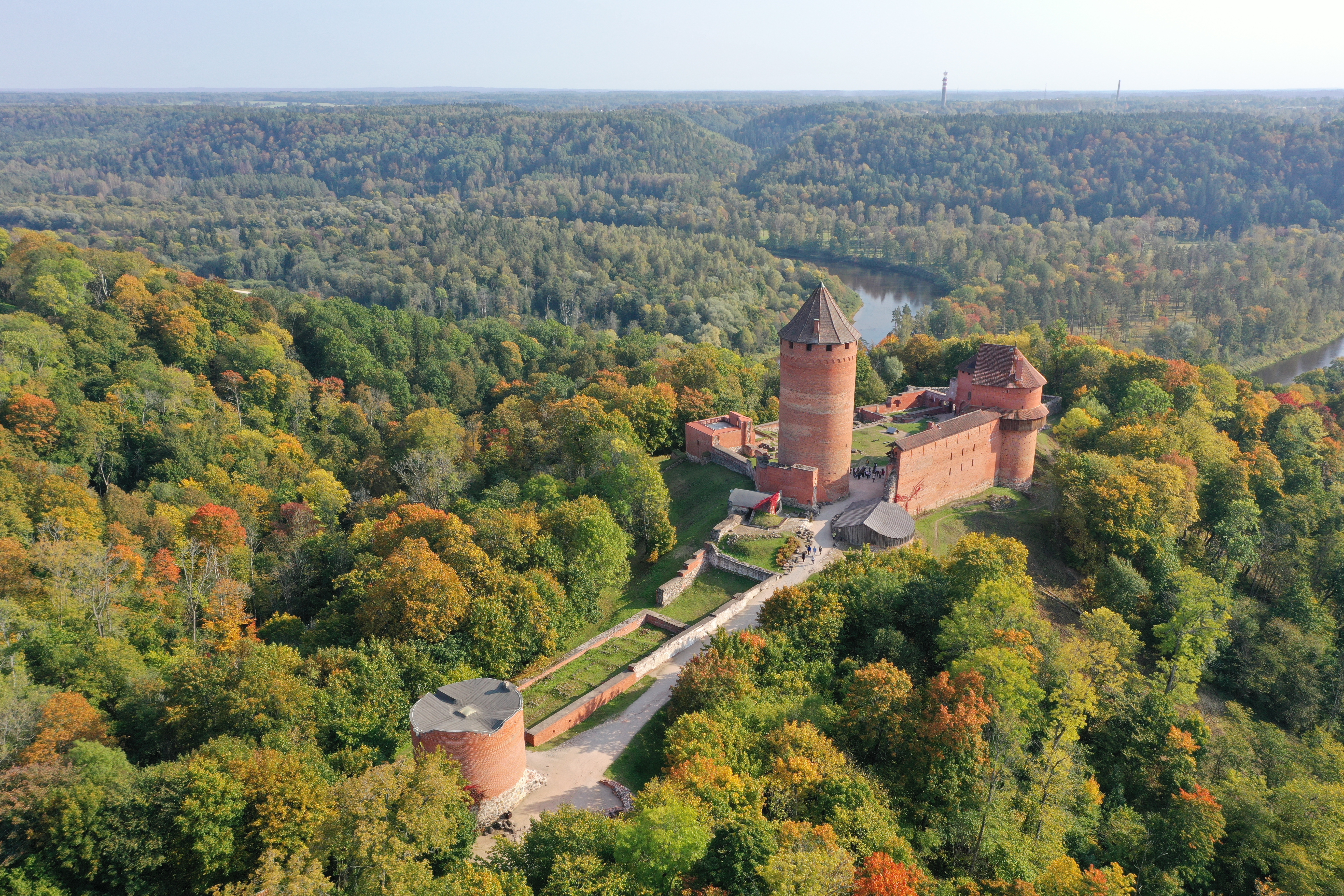
Gauja Primeval Valley and the castle of Turaida
The Gauja primeval valley has been included in the Culture Canon. The river valley from Valmiera to Vangaži has high aesthetical, biological diversity, cultural and historical, and educational value. This part of Gauja can be compared with Germany’s Rhine, France’s Seine, Ireland’s Shannon, Italy’s Po, Hungary’s Danube, and Portugal’s Duoro – Europe’s greatest and most beautiful river landscapes. Poet Ojārs Vācietis in his poem “Gauja”, admiring the artistry of the landscape, writes: “When God created Gauja, he was in love.” In many songs Latvians associate Gauja with their nation’s life.
One of the largest aesthetical treasures of Gauja primeval valley are the view perspectives, which reveals the river gulfs, strait and colourful valley slopes. When walking or cycling on the trails and roads near Gauja valley, between the trees in many places reveals semi-hidden middle view and far view perspectives on the river valley. Although they cannot be compared with breath-taking views from Turaida castle tower, Ērgļu rocks (Ērgļu klintis), mound Paradīzes (Paradīzes kalns or Gleznotājkalans), Ķeizarskats, Ķeizarkrēsls and Sigulda Bobsleigh and Luge Track, where the valley reveals itself in its full beauty.
Most people enjoy this landscape in autumn, when different colours paint the trees that grow in the slopes and river terraces. These various shades are determined by the valley’s vegetation. The riverbed is marked with willow trees, but the valley’s slopes and fluvial terraces are covered in pine trees, spruces, birches and many hardwoods – oaks, ash trees and maples. This multi-coloured vegetation is determined by different geological sediments and many springs that were created when the river tributaries carved in the bedrock. The underground waters are very different in their chemical structure, depending on which rocks they filtrate through. This, in turn, determines the vegetation cover. Due to the valley’s microclimate, different soil conditions, and relatively small changes in the environment in the Gauja floodplain, slopes, fluvial terraces, and especially ravines, there are many protected biotopes on the level of European Union: 91F0 Riparian mixed forests of Quercus robur, Ulmus laevis and Ulmus minor, Fraxinus excelsior or Fraxinus angustifolia, along the great rivers, 9080* Fennoscandian deciduous swamp woods, 9010* Western taiga, and 7220* Petrifying springs with tufa formation in Gauja tributaries and ravines. The human agricultural activity can be distinguished by the European Union specially protected biotopes – 6120 * Sandy grasslands, and 6510 Lowland hay meadows. Gauja and its tributaries are rich with siliceous rocky slopes with chasmophytic vegetation 8220, 7160 Fennoscandian mineral-rich springs and springfens, and 3260 Water courses with the Ranunculion fluitantis and Callitricho- Batrachion vegetation biotopes. Because Gauja river middle course and lower course is transformed very little, the river with its tributaries is one of the few rivers throughout the Baltic Sea basin, where natural lampreys and salmons spawn. Professor Guntis Eberhards, after many researches of Gauja valley, on the huge signification of springs and streams, writes: “its inconsistency and greatness, beauty and attractiveness is doubled by the many springs, streams and tributaries, who give their energy to Gauja for it to always graciously reach the Sea, for the sandbanksalways be golden and the gulfs always sparkle in the sun, for the birds to always sing on the shores, and for all people cheer.”
The long-dominated opinion in the society and scientific community, that there exist primeval conditions on the slopes and terraces of the river valley and that there hasn’t been any economic activity, is overturned by geographer Kamils Ramans. His research revealed that the valley’s relatively natural landscapes have been transformed many times as a result of deforestation and burning of forests. On the valley terraces, slopes and even very steep places Raman detected signs of former clearances. In the beginning of the last century, where now are forests, were meadows and pastures, as well as park-type meadows that are very rare nowadays in the Latvian landscape. Thanks to the cooperation between Latvian Fund for Nature, The Nature Conservation Agency and Turaida Museum Reserve, restoring of park type meadows between Turaida and Sigulda has begun. Although the old meadow landscape with large, separately growing trees and magnificent flower fields below, these park type meadows will have only after decades, with continuous trimming or herding. Professor Guntis Eberhards, based on the toponym “Gauja” possible liv origin from the word “kőw” (birch), notes that even today on the shores of Gauja, on the terraces around Sigulda birches can be found, and that it is possible that formerly the birches here were even more. On the one hand, this can be a sign that birch forests on the shores of Gauja formed after abandoning the clearings, on the other hand – birches were the primary species after the formation of fluvial terraces.
People have lived on the shores of Gauja for hundreds of years. The river served both as a trade road from Scandinavia to Russia and as a border between livs (Fenno-Ugrian peoples) and latgalians (the Indo-Europeans). As time passed, people left their footprints on the valley landscape. Turaida castle, Sigulda, Cēsis and Līgatne are the cultural heritage treasures in the Gauja valley and its shores, which are visited by million tourists each year. The Gauja primeval valley landscape is a staple of Latvia in many tourist brochures. The area around the river is full of ancient castle mounds and burial sites. When travelling along the valley, it is very likely to come across traits of old historical roads on the current forest landscape.
In 1922 three valley objects were included on the list of specially protected forests and parks: Turaida manor forest near Gauja (Turaidas muižas mežs gar Gauju) (190 ha), Krimulda park (72 ha) and Gauja shores (294 ha). Currently all Gauja primeval valley is included in the Gauja National park territory, which was created (1973) for the goal of protected cultural and historical landscape.
Oļgerts Nikodemus


